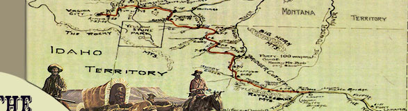
Jim
Bridger was completely familiar with the region of the Big Horn
Basin and the 1864 trail route from his 40 years of experience in
the Rocky Mountains. He also pioneered the Bozeman Trail route for
wagon travel through the Powder River country several years before
John Bozeman's trek in 1863.
In 1859 Captain William Raynolds of the U. S. Army Topographical
Corps was ordered to locate four possible wagon routes through northern
Wyoming and southern Montana. The War Department hoped to build
a network of roads across the Northern Plains and Rocky Mountains
that would open the last stronghold of the Blackfeet and Sioux to
white settlement. The expedition was also instructed to separate
and perform individual reconnaissance; one group exploring the upper
reaches of the Bighorn River, while the other explored the upper
Yellowstone River valley.
On the recommendation of the Choteau
Fur Company, long the headquarters for mountaineers, Raynolds
hired the "best guide," civilian Jim Bridger, to lead
the expedition. Raynolds left Fort Pierre in June, traveling overland
to Fort Sarpy on the Yellowstone River where they arrived in late
August. The fur company had sent provisions upriver by bateaux
to resupply Raynolds and deliver annuities for the Crow gathered
at the fort. With Bridger as guide, the expedition departed Fort
Sarpy and ascended the Yellowstone to the mouth of the Bighorn
River where the expedition separated. Lt. Maynadier took a party
and proceeded southeast to the Rosebud, Tongue, and Powder rivers
and rejoined the main party on the North Platte River in October.
Raynolds continued south up the Bighorn
then left the river for a southern course along the eastern flank
of the Bighorn Mountains. He continued along this route through
the Powder River Basin and reached the Oregon Trail and the upper
Platte Bridge near Red Buttes in October. Reunited, the expedition
established winter quarters on Deer Creek near the Indian Agency
on the North Platte River between Fort Laramie and the lower Platte
Bridge. Exploration would commence again in the spring of 1860.
Raynolds' route south from the Yellowstone
River proved the feasibility of a wagon  road
through the region to the Oregon Trail and established the future
route of the Bozeman Trail. His summary report said in part that
"At the eastern base of the Big Horn
mountains there is a belt of country some 20 miles in width that
is peculiarly suitable for a wagon road, and which I doubt not
will become the great line of travel into the valley of the Three
Forks. Being at the base of the mountains, this strip is watered
by . . . numerous streams. . . . a comparatively straight road
can be laid out close to their foot . . . I traveled through this
region with heavily loaded wagons in the fall of 1859 without
embarrassment." road
through the region to the Oregon Trail and established the future
route of the Bozeman Trail. His summary report said in part that
"At the eastern base of the Big Horn
mountains there is a belt of country some 20 miles in width that
is peculiarly suitable for a wagon road, and which I doubt not
will become the great line of travel into the valley of the Three
Forks. Being at the base of the mountains, this strip is watered
by . . . numerous streams. . . . a comparatively straight road
can be laid out close to their foot . . . I traveled through this
region with heavily loaded wagons in the fall of 1859 without
embarrassment."
Raynolds' report also refers to Jim
Bridger's superior knowledge of the Yellowstone country and along
the eastern base of the Bighorn Mountains. "My American guide,
Bridger is ... on familiar ground and appears to be entirely at
home in this country."
The following spring, Raynolds
and Lt. Maynadier twice traveled separate routes to increase the
reconnaissance of the upper Yellowstone River region and the upper
valley of the Bighorn River. Raynolds
chose to explore the Yellowstone country. Maynadier's exploration
along the upper Bighorn River through the Bighorn Basin provided
the basis for future historians to claim that he was responsible
for the location of the Bridger Trail route utilized by Bridger
in 1864. Maynadier, however, had never been in the country before,
and his guide was not nearly as experienced as Bridger. His route
differed considerably from the trail blazed by Bridger four years
later.
 |
 |
The difference between the two routes
is apparent from a comparison of Raynolds' report and the emigrant
diaries. Regarding the Bridger Trail as a whole, Maynadier did
not traverse the portion between Red Buttes and Badwater Creek;
he did not know of or travel the Bridger Creek/Kirby Creek route
over the Bridger Mountains; he failed to find an adequate road
once in the southernmost region of the Bighorn Basin; he followed
a decidedly different route between the Greybull and Shoshone
Rivers; and he followed a different route once along Clarks Fork
to the Yellowstone River. Therefore, Jim Bridger is given the
credit for locating the Bridger Trail route.
|