|
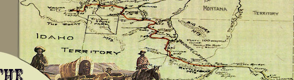
The drive north of the Greybull River
passed through some of the driest country in  the
Bighorn Basin, especially for those trains coming through in July.
To complicate matters, the emigrants had to
first negotiate an upland bench (Emblem Bench), circumvent Bridger
Butte, then make a steep descent down the Devil's Backbone into
the Coon Creek Valley, approximately 8 miles north of the Greybull
River. Following this arduous feat, emigrants were hot, thirsty,
and tired, but the trains still had the majority of the distance
left to reach the Shoshone River, a trip made harder if the ephemeral
streams in the region possessed little or no water. the
Bighorn Basin, especially for those trains coming through in July.
To complicate matters, the emigrants had to
first negotiate an upland bench (Emblem Bench), circumvent Bridger
Butte, then make a steep descent down the Devil's Backbone into
the Coon Creek Valley, approximately 8 miles north of the Greybull
River. Following this arduous feat, emigrants were hot, thirsty,
and tired, but the trains still had the majority of the distance
left to reach the Shoshone River, a trip made harder if the ephemeral
streams in the region possessed little or no water.
 Several
diaries describe the emigrants' parched drive to the Shoshone
River (or "Stinking Water" as it was called) and the
passage over what came to be called the Devil's Backbone. Howard
Stanfield's account is the earliest of the season and the most
detailed. Jacobs' train left the Greybull River on the morning
of June 15, for what Stanfield called a Several
diaries describe the emigrants' parched drive to the Shoshone
River (or "Stinking Water" as it was called) and the
passage over what came to be called the Devil's Backbone. Howard
Stanfield's account is the earliest of the season and the most
detailed. Jacobs' train left the Greybull River on the morning
of June 15, for what Stanfield called a
"tug of war and some of them
nearly tugged out. . . . left . . .  camp
. . . about seven oclock [sic] hoping
to find water in about twelve miles we traveled of terribly dusty
road. . . . we had one fearful ravine to cross but by using rope
to let the wagons down and applying the whip briskly to the animals
in coming up we all managed to get safely across but it was warm
work and a very hot day. . . . we found neither water nor grass.
. . . about noon but we had no inducement to stop but we did have
something to hurry us forwards and that was to find water for
ourselves and stock beside something for animals to eat for we
had almost run out of stock feed and relied solely upon the grass.
. . . to keep our stock in running order so we hurried on giving
the poor things no rest and when we arrived at the next creek
four miles from the last it to [sic] was dry and our only hope
lay in reaching Stinking Water and so we pushed on some of the
stock giving out both men and animals nearly dying for water we
had not counted upon such a long drive and consequently we had
not made necessary provision by laying a supply of water as we
should have done had we known what was before us. . . . reached
Stinking Water about seven in the evening after a long dustry
[sic] thirsty drive of 28 miles. . . . [if] the river had been
much smaller it would have been drained by man and beast combined.
. . . We found no grass that evening the stock had to go hungry." camp
. . . about seven oclock [sic] hoping
to find water in about twelve miles we traveled of terribly dusty
road. . . . we had one fearful ravine to cross but by using rope
to let the wagons down and applying the whip briskly to the animals
in coming up we all managed to get safely across but it was warm
work and a very hot day. . . . we found neither water nor grass.
. . . about noon but we had no inducement to stop but we did have
something to hurry us forwards and that was to find water for
ourselves and stock beside something for animals to eat for we
had almost run out of stock feed and relied solely upon the grass.
. . . to keep our stock in running order so we hurried on giving
the poor things no rest and when we arrived at the next creek
four miles from the last it to [sic] was dry and our only hope
lay in reaching Stinking Water and so we pushed on some of the
stock giving out both men and animals nearly dying for water we
had not counted upon such a long drive and consequently we had
not made necessary provision by laying a supply of water as we
should have done had we known what was before us. . . . reached
Stinking Water about seven in the evening after a long dustry
[sic] thirsty drive of 28 miles. . . . [if] the river had been
much smaller it would have been drained by man and beast combined.
. . . We found no grass that evening the stock had to go hungry."
Cornelius Hedges made the trek on June 17, two days behind Stanfield.
"Started at  7½
drove up from creek up narrow & stony ravine on the highlands.
. . . about 11 came to a steep descent, took the train an hour
to pass--here we saw 5 buffaloes . . . but they got away--passed
two dry creeks. . . . We had a long drive to get to water--many
teams gave out--reached Stinking Water--large stream--no grass."
According to Tom LeForge, "A merchant wagon tipped over a
grade at the `Devil's Backbone' point on the trail. . . . Much
of the cargo was lost, though most of it was recovered. The wagon
was abandoned." 7½
drove up from creek up narrow & stony ravine on the highlands.
. . . about 11 came to a steep descent, took the train an hour
to pass--here we saw 5 buffaloes . . . but they got away--passed
two dry creeks. . . . We had a long drive to get to water--many
teams gave out--reached Stinking Water--large stream--no grass."
According to Tom LeForge, "A merchant wagon tipped over a
grade at the `Devil's Backbone' point on the trail. . . . Much
of the cargo was lost, though most of it was recovered. The wagon
was abandoned."
Charles Baker came through two weeks
after Hedges. His train left the Greybull River on July 6, but
made no reference to the steep terrain along the trail. "Day
warm & very windy Drove 30 mi without grass or water Very
desert country--arrived at Stinking River at 5 O. C." William
Haskell passed a few days later and his diary entry is a poignant
illustration of the day's travel. "Made 24 miles without feed or water for the cattle, till we reached Stinking Fork shortly
after sunset; the cattle were beat out; no feed tonight; went
down some hills today that would frighten the oldest man in America."
Haskell was rewarded the following day for the exhausting trip.
After making eight miles down the Shoshone River the next day,
his train "found good grass and rested the balance of the
day; this is a beautiful rapid river; caught some mountain trout
for supper that would weigh two pounds each."
feed or water for the cattle, till we reached Stinking Fork shortly
after sunset; the cattle were beat out; no feed tonight; went
down some hills today that would frighten the oldest man in America."
Haskell was rewarded the following day for the exhausting trip.
After making eight miles down the Shoshone River the next day,
his train "found good grass and rested the balance of the
day; this is a beautiful rapid river; caught some mountain trout
for supper that would weigh two pounds each."
Major Owen recorded the increasing
difficulties experienced by his train on the trip up until they
reached the vicinity of the Shoshone River, after which his diary
ends. Owen and Bridger departed the Greybull River on October
21, and then encountered the  Devil's
Backbone. Devil's
Backbone.
"Ten Miles on a good road over
rolling Sage plain brought us to a very bad hill--we were longer
getting down the hill than we were travelling the 10 miles--In
fact we were 5 hrs before the last Wagon Was Safely landed on
the flat below. Then in sight of camp some 1½ Miles from
the Hill a Wagon Must turn over &c &c &c. . . . [22nd]
Reloaded the Wagon & Moved Some 10 miles over a good road
to dry fork of Stinking found water in pools & Campd--Bridger
Bgd [sic] 3 Bulls. . . . [23rd] 12 yoke of Cattle lost Lay over
in hopes of finding them but to no purpose--We have Exhausted
the Water we brought from Grey Bull & are using Water the
Consistency & color of good Cream--Failed findg [sic] the
lost Stock. . . . [24th] Moved with what Stock we had in order
to reach water. . . . had to lv [sic] 3 . . . Wagons. . . . [5]
Men remained with them 18 miles to Day."
During the next few days, Owen and
the train laid over on the Shoshone River. On October 25, they
"[s]ent back 18 yoke of Steers to bring up the 3 wagons left
behind--Camp lay over. . . . [26th] Mr Parham took some 30 lbs
of fine trout which were relished by the whole camp. Duster bagd
[sic] a fine Blk Tail Buc [sic]. . . . [27th] Mr P took a fine
string of trout. . . . [29th] Men off fishing getting tired of
laying still." Four yoke of cattle were recovered, but 16
head of cattle appear not to have been recovered.
Once across the Shoshone River, each
train stayed at least one night to rest the stock while water
and grass were available. The emigrants themselves used the time
to recuperate, hunt, fish, prospect, and make needed repairs before
pushing north up Sage Creek and into Montana.
|
 |