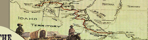
|
"Unquestionably Bridger's claims
to remembrance rest upon the extraordinary part he  bore
in the explorations of the West. As a guide he was without equal,
and this is the testimony of everyone who ever knew him. He was
a born topographer; the whole West was mapped out in his mind,
and such was his instinctive sense of locality and direction that
it used to be said of him that he could smell his way where he
could not see it. He was a complete master of plains and woodcraft,
equal to any emergency, full of resources
to overcome any obstacles, and I came to learn gradually how it
was that for months such men could live without food except what
the country afforded in that wild region. . . . Bridger was not
an educated man, still any country that he had ever seen he could
fully and intelligently describe, and he could make a very correct
estimate of the country surrounding it. He could make a map of
any country he had ever traveled over, mark out its streams and
mountains and the obstacles in it correctly, so that there was
no trouble in following it and fully understanding it. . . . He
understood thoroughly the Indian character, their peculiarities
and superstitions. . . . As a guide I do not think he had his
equal upon the plains." bore
in the explorations of the West. As a guide he was without equal,
and this is the testimony of everyone who ever knew him. He was
a born topographer; the whole West was mapped out in his mind,
and such was his instinctive sense of locality and direction that
it used to be said of him that he could smell his way where he
could not see it. He was a complete master of plains and woodcraft,
equal to any emergency, full of resources
to overcome any obstacles, and I came to learn gradually how it
was that for months such men could live without food except what
the country afforded in that wild region. . . . Bridger was not
an educated man, still any country that he had ever seen he could
fully and intelligently describe, and he could make a very correct
estimate of the country surrounding it. He could make a map of
any country he had ever traveled over, mark out its streams and
mountains and the obstacles in it correctly, so that there was
no trouble in following it and fully understanding it. . . . He
understood thoroughly the Indian character, their peculiarities
and superstitions. . . . As a guide I do not think he had his
equal upon the plains."
--- Grenville Dodge
Biographical Sketch of James Bridger
American Heritage Center
Refer to Acknowledgements #2
A short biography of Jim Bridger
supports the quotation by General Dodge and reveals that Bridger
had few if any equals to his achievements
as mountain man, guide, and entrepreneur.
Bridger had over thirty years experience
in the West as a trapper, mountain man, and Indian fighter before
he became the premier guide for the United States Army in the
mid-1850s. He had traveled extensively in the Rocky Mountain West
with General William Ashley first as an employee and later as
a partner in the famous Rocky  originally made by Bridger for W.M. Collins. First drawn in the earth with a stick- then in detail on the skin of an animal with charcoal. Bridger then gave it to W.M. Collins who made this map. (AHC) Refer to Acknowledgements#2") Mountain
Fur Company. He mastered wilderness lore and accumulated an astounding
mental map of western North America before there were any territories
west of the Mississippi River. It was this geographical knowledge
that aided many U. S. Army Topographical expeditions in the successful
completion of their assignments. Bridger provided from memory
accurate maps of the Rocky Mountains to U. S. military commanders
leading exploratory expeditions. He possessed an intimate knowledge
of western geography and natural transportation routes. He was
also familiar with native inhabitants, especially the Shoshoni.
He was a personal friend of Chief Washakie of the Shoshoni, and
was married three times to native women: a Flathead, a Ute, and
Shoshoni. As a result of his cumulative experience, Bridger played
an integral role in the initial geographical discoveries in the
West, which, in turn, helped foster early Euro-American emigration
and settlement. Mountain
Fur Company. He mastered wilderness lore and accumulated an astounding
mental map of western North America before there were any territories
west of the Mississippi River. It was this geographical knowledge
that aided many U. S. Army Topographical expeditions in the successful
completion of their assignments. Bridger provided from memory
accurate maps of the Rocky Mountains to U. S. military commanders
leading exploratory expeditions. He possessed an intimate knowledge
of western geography and natural transportation routes. He was
also familiar with native inhabitants, especially the Shoshoni.
He was a personal friend of Chief Washakie of the Shoshoni, and
was married three times to native women: a Flathead, a Ute, and
Shoshoni. As a result of his cumulative experience, Bridger played
an integral role in the initial geographical discoveries in the
West, which, in turn, helped foster early Euro-American emigration
and settlement.
Bridger's experience knew no bounds.
He quit the dying fur trade in 1842, and in 1843 with his partner
Louis Vasquez, established a trading post along the Blacks Fork
of the Green River in what is now Wyoming (it was the Territory
of Mexico at the time). Bridger recognized that the overland migration
to Oregon was a sign of changing settlement patterns, and the
construction of Fort
Bridger could not help but become a profitable economic concern.
For the next fifteen years, the post was a key supply point for
Oregon-Mormon-California Trail emigrants needing provisions, livestock,
and wagon repairs.
The Stansbury expedition to the Great
Salt Lake in 1849-1850 was the first federally funded government
exploration guided by Bridger. It was designed to acquire geographical
and geological data about the West that would facilitate a future
route for a transcontinental railroad and telegraph and identify
the location of coal deposits. On the return, Bridger guided Stansbury's
party east along a route that would later become familiar as the
Overland Stage and Union Pacific Railroad routes.
Bridger's unequaled knowledge of
the northern Rocky Mountain region and upper , Refer to Acknowledgements#2") Missouri
River Basin aided two expeditions searching for transportation
routes between 1856 and 1860. He served as guide for Lt. Warren's
1856 expedition to reconnoiter the regions surrounding the Black
Hills and the Yellowstone River. He led Warren's party from Fort
Union, at the mouth of the Yellowstone on the Missouri River,
up the Yellowstone to the mouth
of Powder River. Warren's explorations revealed what geographical
information was still lacking. In his reports on the Dakota region,
Warren recommended further reconnaissance of the upper Yellowstone
and Powder River country, regions that were still classified as
terra incognita. Missouri
River Basin aided two expeditions searching for transportation
routes between 1856 and 1860. He served as guide for Lt. Warren's
1856 expedition to reconnoiter the regions surrounding the Black
Hills and the Yellowstone River. He led Warren's party from Fort
Union, at the mouth of the Yellowstone on the Missouri River,
up the Yellowstone to the mouth
of Powder River. Warren's explorations revealed what geographical
information was still lacking. In his reports on the Dakota region,
Warren recommended further reconnaissance of the upper Yellowstone
and Powder River country, regions that were still classified as
terra incognita.
As a result, Captain William Raynolds
was ordered to explore the region in 1859. Jim Bridger was the
logical choice to guide this important expedition. When the Army
resumed operations against the Sioux after the Civil War, the
Warren and Raynolds' reports formed the only existing body of
information pertaining to the Dakota-Wyoming region.
Whenever the mission was important,
the government's choice was invariably the same: Jim Bridger.
Among other expeditions, he spent part of the year 1857 guiding
Colonel Albert S. Johnson who was sent to escort the new federal
governor and restore the presence of the U.S. government in Utah
Territory during the Utah (Mormon) War. He served in 1861 as guide
for an exploratory party under the command of Captain E. L. Berthoud
for a road through the Colorado Rockies, and he served under Colonel
Collins and his son Lt. Caspar Collins in the early 1860s as well.
Bridger had achieved the rank of
Major and was the chief guide (at $10 a day) assigned to Fort
Laramie throughout the remainder of the 1860s until his retirement
late in 1868. However, he spent the 1864 season guiding emigrant
trains to Montana, after obtaining a leave of absence from the
fort on April 30. On May 20, he guided the first train of emigrants
along the Bridger Trail to the Montana gold fields near Virginia
City. He led a second party along the trail in the fall.
Sioux opposition to emigration and
military activity along the Bozeman Trail intensified in 1865
and Bridger's services as guide were needed more than ever. He
guided the lead column of the Powder River Expedition, under the
command of General Patrick E. Connor, who was ordered into the
Powder River Basin to find and punish the Sioux and their allies.
The campaign failed in its attempt to curtail Indian aggression
along the Bozeman Trail.
Bridger served his last commission
in 1868 following the signing of the Fort Laramie Treaty, which
closed the Bozeman Trail and the forts built in vain to defend
it. He guided the Army to the Powder River Basin to remove the
property from the forts. When he returned, he was paid and discharged
from the Army at Fort D.A. Russell. He retired to his farm in
Westport, near Kansas City, Missouri, and died on July 17, 1881
at the age of 77.
In 1904, on the 100th anniversary
of Bridger's birth, General Grenville Dodge had  Bridger
reinterred at a select spot in the Mount Washington Cemetery in
Independence, Missouri, with a 7-foot monument depicting Bridger's
principal achievements. Bridger
reinterred at a select spot in the Mount Washington Cemetery in
Independence, Missouri, with a 7-foot monument depicting Bridger's
principal achievements.
"Celebrated as a hunter, trapper,
fur trader and guide. Discovered Great Salt Lake 1824, the South
Pass 1827 [1823]. Visited Yellowstone Lake and Geysers 1830.
Founded Fort
Bridger 1843. Opened Overland Route by Bridger's Pass to Great
Salt Lake. Was a guide for U. S. exploring expeditions, Albert
Sidney Johnston's army in 1857, and G. M. Dodge in U. P. surveys
and Indian campaigns 1865-66."
|