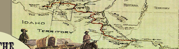
|
Water, forage and food
To the emigrants along the trail
the availability of water and feed for their stock was of paramount
importance. This factor and the physical condition of the road
influenced their decision as much or more than the threat of Indian
hostilities. More than a few emigrants chose to return to the
main Oregon-California trail after a few miles or days on the
Bridger Trail. The majority of travelers in 1864 chose to take
the longer and safer route that was less arduous for themselves
and their livestock. Without livestock, their very means of transportation
was threatened. The only solutions to lost livestock were to acquire
replacements at one of the forts or posts along the trail or to
get substitutes from others in the train who had a surplus of
animals. In general, water and grass were less available along
the Bridger Trail than along the Bozeman Trail. The loss of livestock
was the norm on the Bridger Trail, not the exception, as the Bridger
Trail diaries make clear.
Food supplies were equally essential
for travelers along the distant trails. Bulk commodities such
as flour, beans, rice, cornmeal, sugar, bacon, salt, dried fruit,
and coffee were initially brought along. These supplies could
be replaced or augmented at the established forts along the trail.
Some emigrants, like Howard Stanfield, departed home overloaded
with too many supplies, and early on had to ship surplus goods
home or sell them along the trail to lighten their loads. An abundance
of game in some regions provided supplies of fresh meat that were
a welcome addition to the otherwise monotonous trail fare.
The first 75 miles: bad water
and poor pasture
The most prevalent observation by emigrants in 1864 along the
first 75 miles of trail was the lack of good water, or any water
at all, and limited pasture for their animals. Howard Stanfield
recalled during the first week in June that "the first three
or four days on the new road feed and water were most fearfully
scarce that we crossed what was almost a desert 70 miles in width
on which we had a tight pinch to get grass for our stock."
Albert Brubaker found "nothing but alkali water to drink"
and several trains were forced to dig wells in dry stream beds
in to get water for their stock. Frank Kirkaldie was with one
of the last trains to travel the trail that summer. He noted that
"The first 60 or 70 miles of the new road passes over a country
which is as near a desert as anything I ever wish to see….There
was absolutely no grass or water, except at a few points where
we camped and we were obliged to make some long drives without
feed or water, 20 and 25 miles…."
These harsh conditions forced some
emigrants from at least three trains to quit the Bridger Trail
and return to the main Oregon-California Trail. Albert Brubaker
traveled only 9 miles along the Bridger trail before turning back.
His reasons for turning back were the bad water and the poor condition
of the road. He wrote, "the cut-off was just like a new road
through sage brush….it was too hard on the mules." Those
that did press on risked losing their stock. Major Owen on September
24th mentioned seeing "the remains of quite a number of dead
oxen strewn along the road."
Over the Bridger Mountains to
the Bighorn River
Water and feed ceased to be such a serious problem once the emigrants
reached Badwater Creek at the base of the Bridger Mountains. Most
emigrants found their first good supply of water and grass on
Bridger Creek (originally known as Willow Creek) just north of
Badwater Creek. Most of the trains stopped at this location to
rest their tired stock and recuperate. William Haskell reached
Bridger Creek on June 30th. He "drove six miles and camped
on a nice creek with an abundance of grass." This should
have been a welcome relief after losing "the best animal
in the outfit" the day before. A day later he chose to stay
behind a day and rest his stock before continuing on.
Bridger Creek provided a practical
and well-watered, but rough uphill, route over the mountain range.
Cornelius Hedges described the trail on June 9th as "hard
and hilly." Major Owen "Traveled 11 miles over a very
rough country road generally good but found some Very steep grades
obliged to double team in two instances…. Camped in a small
Vally [sic] on willow creek finding a plentiful supply of good
grass and water."
Near the summit the road became more
rough and narrow as described by William Haskell on July 3rd.
"Traveled till about 10 o'clock tonight to find water for
the cattle. The road run over Mountain peaks where there was just
room enough for the wagons to pass; two feet off either side would
have sent us down hundreds of feet below; in some places it took
us all to keep the teams in the road and the wagon right side
up; we made but a short drive today, there was so much doubling
of teams…." Major Owen also had trouble with the pass.
On October 1st he described "hard pulling up the Hill. Turned
over one of Col Vaughns Wagons on the Hill & another close
to our camp …."
After crossing the summit the travelers
went down the Kirby Creek drainage to the Bighorn River. Several
emigrants mentioned running out of water on this stretch later
in the summer and had to send riders ahead to bring back water.
On July 4th William Haskell wrote "…. we traveled on
eight miles, but could find no water. We drank vinegar ….
we had emptied our water kegs completely. Abe took the pony and
went to find water; luckily after riding six miles he came to
the Wind [Bighorn] River, borrowed a keg of some emigrants camped
there and brought it back full of water…"
Along the Bighorn River
The drive north along the west side of the Bighorn River provided
ample water during
 the next few days of the trip, but the trail was tough going.
On July 1, Baker "drove 14 mi. & camped….Roads very
rough tho not hilly…" The rough going was due to the
sandy soil along the river. Haskell came along a few days later
on July 6th and "(t)raveled fifteen miles over awfully hilly,
sandy roads, hard on the teams; another ox pegged out today which
has sadly reduced our team."
the next few days of the trip, but the trail was tough going.
On July 1, Baker "drove 14 mi. & camped….Roads very
rough tho not hilly…" The rough going was due to the
sandy soil along the river. Haskell came along a few days later
on July 6th and "(t)raveled fifteen miles over awfully hilly,
sandy roads, hard on the teams; another ox pegged out today which
has sadly reduced our team."
From the Bighorn River to the
Greybull River
This stretch of trail from the Bighorn River northwest to the
Greybull River was the first of two long drives without water
or feed. Baker's train experienced no real hardships, but mentions
the lack of water and grass. On July 4, they "left the Big
Horn River & traveled 20 mi. further over very desert country
- no grass nor water till we came to Gray Bull [sic] Creek - plenty
of wood & grass." Major Owen described this portion of
the route on October 16. "Left the B.H. river Six miles through
heavy Sand to divide some 9 Miles further through the Bad lands
to Grey Bull Creek a pretty stream emptying into B.H."
On the Greybull
Once on the Greybull, natural resources increased significantly.
This provided an opportunity for some trains to hunt, fish, and
rest their stock. For example, Stanfield noted on June 12th that
the hunters killed buffalo and Ethel Maynard recalled that "everyone
had a good feast of fish. I caught about as many as I could carry
and others did the same." Owen and Bridger spent 4 days on
the Greybull River and on October 19th Owen wrote, "Lay over
to rest the cattle Lyon asst W.M. [wagon master] Bagd (sic) a
fine Deer George…caught a fine string of trout…."
The Devil's Backbone: The Greybull
River to the Shoshone River
This was the second and more difficult drive without water and
feed since leaving the Bighorn River. Several diaries describe
the emigrants' parched drive north to the Stinking Water (Shoshone)
River and the harsh passage over what came to be called the Devil's
Backbone. Howard Stanfield's account is the earliest of the season
and the most detailed. His train left the Greybull River on the
morning of June 15th, for what Stanfield called a
"tug of war and some of them
nearly tugged out …. left … camp…about seven oclock
[sic] hoping to find water in about twelve miles we traveled of
terribly dusty road …. we had one fearful ravine to cross
but by using rope to let down the wagons and applying the whip
briskly to the animals in coming up we all managed to get safely
across but it was warm work and a very hot day….we found
neither water nor grass …. about noon but we had no inducement
to stop but we did have something to hurry us forwards and that
was to find water for ourselves and stock beside something for
animals to eat for we had almost run out of stock feed and relied
solely upon the grass …. to keep our stock in running order
so we hurried on giving the poor things no rest and when we arrived
at the next creek four miles from the last it to [sic] was dry
and our only hope lay in reaching Stinking Water and so we pushed
on some of the stock giving out both men and animals nearly dying
for water we had not counted upon such a long drive and consequently
we had not made necessary provision by laying a supply of water
as we should have done had we known what was before us….reached
Stinking Water about seven in the evening after a long dustry
[sic] thirsty drive of 28 miles….[if] the river had been
much smaller it would have been drained by man and beast combined….We
found no grass that evening the stock had to go hungry."
From the Shoshone River to the
Clarks Fork
Once across the Shoshone River, each train stayed at least one
night to rest the stock while water and grass were available.
The emigrants themselves used the time to recuperate, hunt, fish,
prospect, and make needed repairs before pushing north up Sage
Creek into Montana for another long drive of approximately 27
miles to reach Clarks Fork of the Yellowstone River. The trail
up Sage Creek was "sandy and hard" according to Hedges
on June 21. On July 15, Haskell "drove 25 miles...roads very
sandy...no water until we camped." Once the trains reached
the Clarks Fork, emigrants could look forward to an abundance
of water, grass for their stock, and fish and game to supplement
their diet.
Summary
Travel over the Bridger Trail appears to have been more difficult
than the Bozeman or Oregon Trail-Montana Trail routes to Virginia
City. Overall, water and grass were less abundant, and the landscape
was more severe for the emigrants and their stock. The Bozeman
and Bridger Trails were both shortcuts of similar mileage. The
Bozeman provided the best water, grass and game, but it also had
increased possibility of Indian attack. The Bridger Trail offered
a safer route in terms of Indian hostilities, but at the expense
of water, grass, game and a harsher landscape over the Bridger
Mountains and the Devils Backbone. It also had two additional
river crossings, the Greybull and the Shoshone, the latter especially
could be difficult to cross. However, in 1864 far more emigrants
chose the Bridger Trail than the Bozeman Trail. The reason may
well have been the persona of Jim Bridger himself. As Frank Kirkaldie
stated, "Bridger's [Trail], is much more popular, probably
from the fact that Bridger is an old and well known mountaineer,
having spent his whole life among the mountains and the Indians
and having the reputation of being a reliable man. He holds a
commission of Major in the U.S. Army and has been much in the
employ of the Govt."
|