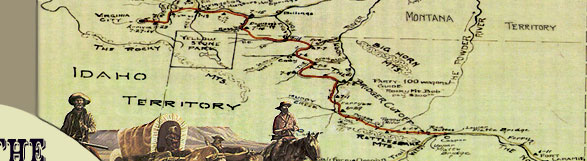
|
Before reaching the Shoshone River
Crossing the Bridger Trail passed through some of the driest country
in the Bighorn Basin, especially for those trains coming through
in July. The distance from the Greybull River north to the Shoshone
River was approximately 27 miles. The trail went due north across
Emblem Bench for approximately 4 miles, crossed Dry Creek and
passed southwest of Bridger Butte. It then went north for about
3 miles to the descent of "Devil's Backbone," a typical
badlands environment of severely eroded multi-colored residual
clay soil with very little vegetation and then crossed the forks
of Coon Creek. The trail continued northwest for about 5 miles,
crossed Whistle Creek, and then proceeded north and east approximately
9 to 10 miles before reaching the Shoshone River east of Roan
Wash.
Howard Stanfield's train left the
Greybull River camp early on the morning of June 15; "a part
of us reached Stinking Water [Shoshone River] about seven in the
evening after a long hot dustry [sic] thirsty drive of 28 miles."
Cornelius Hedges wrote on June 17, "We had a long drive to
get to water--many teams gave out--reached Stinking Water--large
stream." Charles Baker's train arrived at the Shoshone River
three weeks later. On July 6, he "[d]rove 30 miles without
grass or water--Very desert country--arrived at Stinking River
at 5 O.C. Went down 2 mi. & camped." William Haskell's
train pulled up to the river on July 11, "Made 24 miles without
feed or water for the cattle, till we reached Stinking Fork shortly
after sunset."
The first three trains, led by Jim
Bridger, John Jacobs, and Captain Allensworth, respectively, were
within a few days of each other from the time of their departure
at Red Buttes. This is evident by the reference to the use of
the ferry at the crossing of the Bighorn River. In fact, on June
17 Hedges "Met two of Bridger's men and found they were only
12 miles ahead."
By June 18, four trains, including
the small train of independents, were now camped on the north
side of the Shoshone. Bridger's lead train had
traveled slower than the rest, because he located the initial
route and did some work on the road. The two trains led by Jacobs
and Allensworth had caught up to Bridger, who was resting on the
north side of the river. Howard Stanfield, a member of Jacobs'
train, wrote on June 18, "We are at the same camp we had
last night where we have remained all day we are the middle train
of three. Bridgers numbering one hundred wagons ½ mile
ahead and Allensworth consisting of 88 wagons just crossed the
River today so there are a goodly number of white men in this
part of the country at the present time." Cornelius Hedges,
a member of Allensworth's train, wrote on June 18, "Bridger's
and Jacob's [sic] trains near us All sorts of stories--206 miles
on the Cut-off." Although their arrival at the river was
somewhat staggered, their layovers overlapped, as each train stayed
encamped for approximately three days. This cumulative presence
of Euro-Americans in 1864 was undoubtedly the largest concentration,
to date, of non-Indians ever assembled in the Bighorn Basin.
The Shoshone River was a suitable
location for resting stock and emigrants after the
 long,
dry, arduous push north of the Greybull. Once across the Shoshone
River, each train stayed at least one night to rest the stock
while water and grass were available. The emigrants themselves
used the time to recuperate, hunt, fish, prospect, and make needed
repairs before pushing north up Sage Creek and into Montana. long,
dry, arduous push north of the Greybull. Once across the Shoshone
River, each train stayed at least one night to rest the stock
while water and grass were available. The emigrants themselves
used the time to recuperate, hunt, fish, prospect, and make needed
repairs before pushing north up Sage Creek and into Montana.
The 1884 GLO plat maps distinctly
show that once the trail reached the Shoshone River it followed
the river to a ford downstream. This is corroborated by what the
diarists said of traveling downstream once they reached the Shoshone
River. Hedges reached the river on June 17, and the next day "drove
on about 5 miles. . . . Crossed Stinking Water -- Several streams,
some deep and swift--safe over. . . . Bridger's and Jacobs' trains
near us." Baker's train arrived at the river on July 6, then
proceeded downstream "2 mi. & Camped." The next
day he "drove down the river 12 miles" and on July 8,
"crossed 2 channels of river." Haskell reached the river
on July 11 and the next two days moved downstream. On July 12,
he "[d]rove eight miles after an early start. . . . [July
13] Drove down the river six miles and found Collin's train camped
there. . . . [July 14th] the whole party . . . crossed the river."
This route is different than the
one Maynadier took four years earlier. When Maynadier arrived
at the Stinking Water (Shoshone) River, he  traveled
upstream along the river to the west-southwest for about 15 miles,
searching for a place to ford the river. No suitable place was
found, and an attempt to get a raft across made out of a wagon
bed proved futile as well. This activity occupied all of June
8 and 9. Finally, on June 11, Maynadier crossed the Shoshone,
but paid a price. Four mules, an ambulance, equipment, and instruments
were lost in the swift current. "Returning to camp I found
that only a box of stationary, which had floated, had been recovered;
everything else must have sunk as soon as the ambulance turned
over, and any effort to recover anything at the bottom of the
river would have been madness." Among the articles lost were
several rifles and assorted personal weapons, "also a sextant
and horizon, three chronometers, and three barometers." traveled
upstream along the river to the west-southwest for about 15 miles,
searching for a place to ford the river. No suitable place was
found, and an attempt to get a raft across made out of a wagon
bed proved futile as well. This activity occupied all of June
8 and 9. Finally, on June 11, Maynadier crossed the Shoshone,
but paid a price. Four mules, an ambulance, equipment, and instruments
were lost in the swift current. "Returning to camp I found
that only a box of stationary, which had floated, had been recovered;
everything else must have sunk as soon as the ambulance turned
over, and any effort to recover anything at the bottom of the
river would have been madness." Among the articles lost were
several rifles and assorted personal weapons, "also a sextant
and horizon, three chronometers, and three barometers."
In 1864 the individual emigrant trains
arrived at the Shoshone River farther upstream than Maynadier
probably because they went farther up the Greybull River than
Maynadier before heading north. They then proceeded downstream
to the crossing. This approach is virtually opposite that of Maynadier.
For example, Charles Baker's train arrived at the Shoshone on
July 6, "arrived at Stinking River at 5 O.C. Went down 2
mi." The next day, he "[d]rove down the river 12 miles
& stayed over night." On July 8, he "crossed 2 channels
of the river." The GLO survey maps for 1884 also show the
Bridger Trail following the south side of the Shoshone River downstream
for 10 miles before crossing to the north side. Clearly, the description
of the route taken by Maynadier between the Greybull and Shoshone
Rivers is different from that of the Bridger Trail route four
years later.
|
 |